
Defining the Usable Area Between Steep Slopes and Setbacks With a Boundary Survey
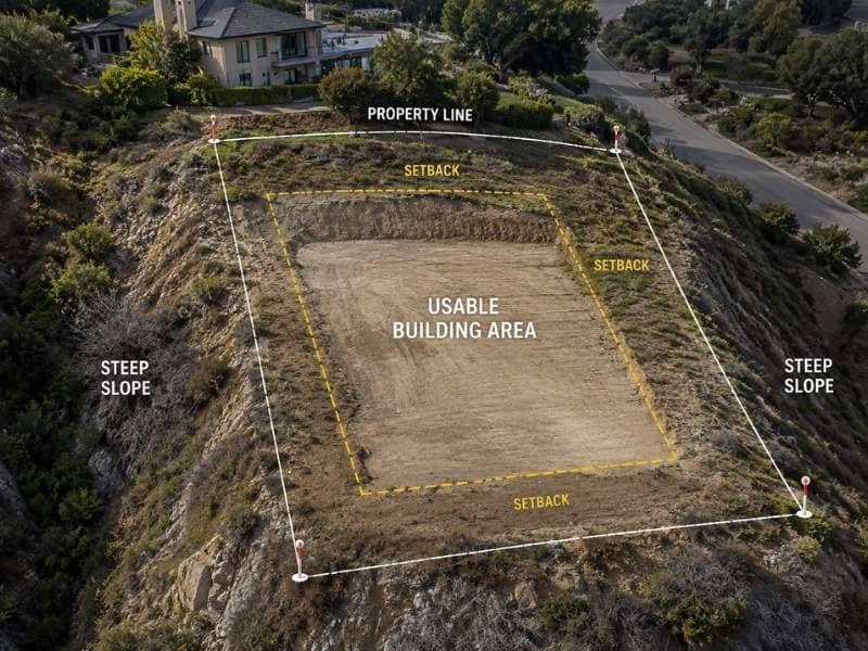
Anyone building on a sloped lot asks the same question. How much of this land can I actually use? A boundary survey answers part of that question. It finds the legal edges of the property and the setback lines inside them. Slope matters too, but it only becomes useful once the true property lines are set.
Steep ground and strict yard rules often work together to shrink the usable part of a lot more than an owner expects. Getting a clear picture of both the legal limits and the physical land early can save time and money later, when design choices are harder to change.
Establishing the Legal Parcel Before Measuring Constraints
A property’s lines come from deeds, plats, and monuments found in the field. They do not come from an old fence or a hedge that has grown there for years. Surveyors check the public record, then find physical proof on the ground to confirm where those lines truly sit.
Slope numbers do not mean much until this step is done. A grading plan built around the wrong corner can send an entire project the wrong way. So the legal parcel comes first. Once those lines are set, every other measurement on the site can tie back to something solid.
Plotting Required Yard Lines Inside an Irregular Lot
Setback rules pull the buildable area inward from every property line. On an odd shaped lot, this can leave a building envelope with a strange shape. A lot that looks big on paper may leave very little real space once every yard rule is applied.
Corner lots, curved lines, and narrow parcels each bring their own challenges. The surveyor plots these setback lines right onto the boundary drawing. This gives the design team a clear picture of where building is legally allowed, before slope or drainage even come into play.
Showing Where Significant Grade Changes Enter That Envelope
Once the buildable envelope is set, the next question is how much of that space you can really use given the slope. Steep grade changes can cut straight through an otherwise buildable area. This can shrink it further in ways that a simple boundary drawing will not show.
This is where legal lines and real terrain start to meet. A corner of the envelope near a property line might sit on a steep slope. Flatter ground might exist elsewhere on the lot, but outside the setback zone. Seeing both sets of facts together helps a team find the true buildable area.
Checking Easements That Further Narrow the Available Space
Setbacks are not always the only limit on a lot. Easements for utilities, drainage, or shared access can remove more space from use. Sometimes these run right through the same spot where a slope already limits building.
A few common examples include:
- Utility easements running along a rear or side line
- Drainage easements following a low point across the lot
- Shared access easements that serve a neighboring property
- Older easements that may not show on the surface but still hold legal weight
Each one can shrink the final buildable area. This is why a boundary survey often includes a search for recorded easements, along with the field measurements.
Delivering a Constraint Map for Professional Site Planning
The final product from this kind of survey is a drawing. It layers legal lines, setback lines, easements, and terrain features into one map. Design teams use this constraint map as the base for site planning. The survey itself does not decide if the project will work.
That difference matters. The survey shows what exists and where the legal limits sit. Decisions about grading, drainage, and final building placement rest with the architects, engineers, and other pros who turn that information into a real plan.
Frequently Asked Questions
Is the area inside the setbacks automatically suitable for construction?
No. Terrain, drainage, utilities, soil, and other rules may still affect whether that space can truly be used.
Can a boundary survey include slope information?
Yes, when topographic measurements are added to the requested scope. This combines property limits with height data in one drawing.
Who makes the final buildability decision?
The permitting agencies and the design professionals working on the project decide whether the proposed building can move forward.